Reviews of Android Apps for your Mobile Device
Here's our review of some really cool apps for Android
mobile devices available from Google Play...
Also: see our Samsung
Galaxy smartphone review
Other product reviews | Two Way Radios | Digital Camera | DV
Camcorder | GPS Sat Nav receiver | Talkie Walkies
This page forms part 2 of our Samsung smartphone review.
Reviewed March 2013 + later updates within.
This page should now be considered an archive resource (although the
principles may still apply).
Intro
 So having explored
the stock applications on our Android powered mobile device, next up
was to install some awesome apps from the Google Play store and extend
the functionally of our smartphone to suit our requirements and
lifestyle... So having explored
the stock applications on our Android powered mobile device, next up
was to install some awesome apps from the Google Play store and extend
the functionally of our smartphone to suit our requirements and
lifestyle...
Downloading and Installing Android Apps from Google Play
First up you'll need a Google account, if you don't already
have one it's easy enough to do on the mobile device when launching
Google Play for the first time. We ran into a little problem here
as it didn't recognise our existing Google account of eight years
standing, so had to set-up another one, which, OMG, came with another
(unneeded) gmail address. Once registered though it's simply a
matter of browsing the extensive Play store, checking out apps that
appeal, reading user comments, app ratings and screenshots; and
clicking 'install'. Many Android apps are free (often supported
by advertising), others cost a small amount. We prefer studying
Google Play apps on a larger computer for ease of reading, and if
signed in with Google account they can be sent straight to your Android
device.
Our five key points on managing apps on an Android
smartphone or tablet:
- stay secure: only download Android apps from the official
Google Play store
- once installed, review the app's settings menu to get the
most out of it and nail security and privacy
- try free versions of apps first, if the ads annoy or extra
functionality is required then consider the paid version
- update installed apps regularly to benefit from
security and bug fixes, added features and improved app function
- there's plenty of apps: try alternatives if the app you
installed doesn't quite cut it
Just quickly at this point: the mobile device's Applications
Manager is used to manage installed apps, check app version, clear data
and the apps cache. You'll find it in the settings menu of your
Android device.
The following Android apps are a selection of ones we've
tried. While perusing, please remember that the world of apps is
constantly evolving; apps come and go, get updated, some improve and
some worsen, and you may well find better ones. And also
remember, these are ANDROID apps; not Apple iPhone apps, not for
Blackberry or Windows phones either, although some have other mobile
device versions too. OK, so let's take a look at some of the
Android apps we've used, together with our tips. We'll probably
add to this in time as we discover more juicy Android apps!
Updates: look out for these below our Android apps
reviews to check how we find them developing over time. There are
also users' comments on the apps on Google Play but be wary - users
ignorant of settings or how-to-use can condemn apps unfairly!
Avast mobile security
Now we've seen discussions on whether a security utility is really
necessary on a mobile device, there are a number of highly rated
anti-virus apps on Google Play and we plumped for Avast because that's
what we use and trust on the PC. There's a virus scanner and
firewall, shields for web/email and the installed apps, plus an
anti-theft program and useful functions such as a network meter and
privacy adviser. Our tip: the firewall doesn't function
without root access to the smartphone which our Samsung Galaxy doesn't.
Update Mar '14: works well, various improvements over
the year.
Update May '15: recently an update decided it couldn't
install, and caused the play store to lose its list of our installed
apps. However Avast quickly released another update which fixed
things.
Update May '16: no issues, frequent updates and works well.
QR Droid
This can scan both QR codes and normal barcodes using the device's
camera for instant decoding or storing, and a saved QR image or code
URL decoded. A barcode can be entered manually, and QR codes
created. Our tip: most QR codes we've scanned out and
aboutUpdate May '16: keeps notifying of update but then says our device
is incompatible! But works well despite this.
carry a URL so a network connection is needed, or store and decode
later.
Update Mar '14: updates have changed the interface and
operability for the better.
Update May '15: various UI changes and extra app functions.
Update May '16: regular updates, new look UI, various
sorting functions.
Google Goggles
Show it a photo of a distinctive building, landmark, product, book,
logo, etc. either from the phone's camera or photo gallery and have
Google tell you all about it. It can also decode QR and barcodes
and translate text. Well, we threw it some 'live' on our 2012
travels and from our extensive tourism image
galleries; while it correctly identified Brighton Pavilion,
Stonehenge, Glastonbury Tor and the Isle of Wight Needles it failed
with the iconic Lancaster bomber and Cornwall's historic coastal mining
towers. Our tip: don't expect miracle matches as it's pretty
hit and miss. The 'visually similar objects' it comes up with as
alternatives are farcical, such as images of clothing in place of those
mining towers! Doh!
Update Mar '14: simplified operation but the
recognition ability is no better!
Update May '15: not seen many updates recently.
Update May '16: not getting updates on our old Android
2.3.6.
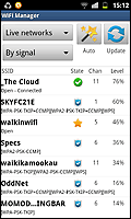 Wi-Fi Manager Wi-Fi Manager
This is far better than most mobile devices own Wi-Fi control, what
with its easier-to-view light skin, three ways to display signal level
(bars, percent, dBm), channel number and network state display, and
previously connected to networks store plus sorting and scanning
options. Screen widget options provide a variety of network info
including speed. Our tip: use the radar display to identify
the best channel to use at home/office as it shows overlap extent in
saturated Wi-Fi locations.
Update Mar '14: can now assign own icons and
descriptions to replace convoluted network names and there's now a
useful single-tap network switcher.
Update May '15: many behind-the-scenes changes and some
extra widgets.
Update May '16: some changes to settings, runs fine.
Right. Wi-Fi manager showing
available Access Points and status.
Navigation and Mapping apps for Android
Our niche this - and a major reason for us getting a smartphone mobile
device. Not quite a replacement for all those paper maps; after
all, what if the battery quits, or the normally reliable GPS can't
lock-on, or there's no network or Wi-Fi? But most of these apps
are a great companion, some integrate together so we're often running
in a multi-app environment while out and about, and we'd sure be lost
without them now...
Google Earth
Really a slimmed downed version of the desktop GE showing the familiar
satellite view but using your current location (or searched one) to
display the map. Pinch and twist gestures control the view which
annoyingly slants while dragging but is easily corrected with a touch
of the compass symbol. A drag-up panel (well, that's what we call
it!) shows a selection of local images. With only sevenselectable
layers it is slimmed down though. Works well enough but the stock
Google Maps app does much the same thing. Our tip: as the map
is cached until user-cleared, scroll it around the area you're visiting
to cache it before leaving home. But clear this later - there's
no option to use the external memory card and it quickly chomps through
limited phone memory!
Update Mar '14: now has a tour guide and 3D imagery.
Update May '15: we don't use Earth much now as the Maps
app does much the same.
Update May '16: no updates for our ancient device system.
Navfree World
 If you read our smartphone review you'll remember we
were disappointed with the smartphone's pre-installed Google Navigation
app. So we came up with this app which had the offline
functionality we required. We downloaded the UK & ROI map
(260MB!) plus the UK postcodes database and 'Kate' and 'Dave', the
English speaking voices for turn-by-turn guidance. The app can
work out a route from a postcode or address, or a destination searched
for and pinned on the map. Options include: vehicle type; such as
car, truck or walking; and fastest, shortest, economical; and avoid
tolls, motorways. Speed camera warnings can be set too and the
route previewed. Your home location can be saved, as can
favourites and recent destinations are stored. The map can be set
to 3D or 2D view and to zoom in at junctions, and overlaid info
includes current speed, distance countdown-to-turn and ETA or time
until arrival. It also shows points of interest (POI) and the
many POI categories can be toggled on/off. A neat feature is that
nearby POI's can be searched (offline too), so you'll be able to find
the nearest café after your journey! And it all worked very well,
the map and direction arrows keeping up with driving progress, and
another neat touch is the auto-night mode when the map changes to a
darker version at sundown. If you read our smartphone review you'll remember we
were disappointed with the smartphone's pre-installed Google Navigation
app. So we came up with this app which had the offline
functionality we required. We downloaded the UK & ROI map
(260MB!) plus the UK postcodes database and 'Kate' and 'Dave', the
English speaking voices for turn-by-turn guidance. The app can
work out a route from a postcode or address, or a destination searched
for and pinned on the map. Options include: vehicle type; such as
car, truck or walking; and fastest, shortest, economical; and avoid
tolls, motorways. Speed camera warnings can be set too and the
route previewed. Your home location can be saved, as can
favourites and recent destinations are stored. The map can be set
to 3D or 2D view and to zoom in at junctions, and overlaid info
includes current speed, distance countdown-to-turn and ETA or time
until arrival. It also shows points of interest (POI) and the
many POI categories can be toggled on/off. A neat feature is that
nearby POI's can be searched (offline too), so you'll be able to find
the nearest café after your journey! And it all worked very well,
the map and direction arrows keeping up with driving progress, and
another neat touch is the auto-night mode when the map changes to a
darker version at sundown.
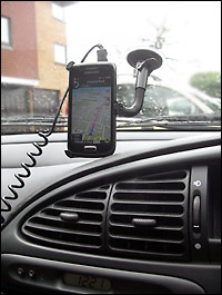
Car mounted smartphone in Sat Nav mode. We
prefer it vertical to see more of the route ahead, but the power lead
is a bit of a stretch.
So are there any shortcomings? Well, yes, a few. We
first used it on our 2012 Wiltshire
holiday and generally Navfree World worked really well,
journey-time estimations were pretty good, although it sometimes took a
while to reroute if we dared to stray from that calculated. We
found the speed camera/speed limit is not shown without a network
connection (fair enough), and while not the app's fault, our
smartphone's top positioned mini USB power input means the necessary
(because the GPS and screen's on constantly) curly car power lead is a
bit of stretch. 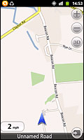 Oh, there's no pinch-to-zoom on
the map, it has + and – buttons instead which is less intuitive driving. Oh, there's no pinch-to-zoom on
the map, it has + and – buttons instead which is less intuitive driving.
And what about pedestrian navigation? This is where it
really falls down as it steadfastly refuses to follow a trail when
navigating in walking mode, instead stubbornly trying to redirect us to
the nearest road. Also the map can lack detail out in the sticks
and many trails are not shown. Finally, it's missing features
such as lane guidance, IQ Routes and HD Traffic but hey man, we're
splitting hairs here - it's free... so not at all bad for that. Our
tip: fine for casual use, but get a dedicated Sat Nav if you're a power
user!
Update June '13: a version update (& map update)
has improved UI and walking mode, but substantially increased system
memory demands.
Update Mar '14: the memory zapping (above) was quickly
fixed but other functions get screwed then fixed with each
update. The 2D/3D map view switching is now more convoluted and a
recent update rendered the stored map unavailable; we had to download
it again.
Update May '15: the latest updated version, Navmii, isn't
compatible with our phone. Original still works well though.
Update May '16: no longer able to update map, POI and
postcodes database on our old phone version.
Right. Walking at 2 mph the trail
abruptly ends on the map, but continues on ahead in reality.
c:geo
 Indulging our geocaching treasure hunting activity was
a key reason for getting a mobile device in the first place, so we
checked out the apps that could work offline and c:geo got good reviews
and seemed to fit the bill. The offline map is first downloaded
(400MB for Britain map!) and stored somewhere on the smartphone, we
chose our ext. microSD. Next, (online) we entered our geocaching
login, waded through the settings page, and used the search to find
caches for our then forthcoming 2012 Wiltshire holiday. With
GPS enabled, caches can be found for the local area, or the map
scrolled to an area of interest. Cache icons are shown on the
map, types filtered, and bulk-stored for later offline use; this stores
the cache info, previous logs and photos, plus helper static map
images. Caches can also be imported from a GPX file. After
that the app can be used entirely offline, using the map and app's
compass to navigate to the cache. Info displayed includes key
cache data, bearing and distance to target. Once found, an
offline log can be completed for later upload. Of course online
maps can be used too, such as Google map and satellite view. Indulging our geocaching treasure hunting activity was
a key reason for getting a mobile device in the first place, so we
checked out the apps that could work offline and c:geo got good reviews
and seemed to fit the bill. The offline map is first downloaded
(400MB for Britain map!) and stored somewhere on the smartphone, we
chose our ext. microSD. Next, (online) we entered our geocaching
login, waded through the settings page, and used the search to find
caches for our then forthcoming 2012 Wiltshire holiday. With
GPS enabled, caches can be found for the local area, or the map
scrolled to an area of interest. Cache icons are shown on the
map, types filtered, and bulk-stored for later offline use; this stores
the cache info, previous logs and photos, plus helper static map
images. Caches can also be imported from a GPX file. After
that the app can be used entirely offline, using the map and app's
compass to navigate to the cache. Info displayed includes key
cache data, bearing and distance to target. Once found, an
offline log can be completed for later upload. Of course online
maps can be used too, such as Google map and satellite view.
We've far from covered everything the app does (eg. see radar
mode in our next app review), but that's what c:geo does in a
nutshell. So how does it perform? Actually, not bad at all,
although we've had a few issues. Firstly, sometimes not all
caches we know to be there in an area are loaded (yes, we checked we
didn't have filters enabled!), and sometimes the 'store for offline' is
greyed out, then we have to painstakingly store each individually from
the cache icon menu. We also found that when stored caches are
dropped the associated files and folders are not actually deleted, as
this chomps into the memory we delete these manually. And while
not the app's fault, the battery is caned on a day's caching, what with
GPS and screen on (with a high outdoor brightness) continually, we can
easily get through three charged batteries. One final
issue. Our old dedicated Garmin GPS receiver
is designed for rugged knock-about outdoor use, our smartphone isn't, so care is
required despite the rubberised grippy surround we fitted. But
overall we're very happy with this app so didn't venture to try others,
and as it gets frequent updates those bugs we highlighted may well be
fixed now for our new 2013 caching season (update June 13: not fixed
yet). Our tip: even when not geocaching the offline map
facility is handy, just to pinpoint where you are.
Update Mar '14: regular updates from the c:geo
developer ensure this remains an awesome app. The ability to add
notes now to each stored cache is a useful addition and the bug where
not all caches were shown appears to be fixed. We've also
downloaded updated OSM maps (from mapsforge)
to keep things accurate.
Update May '15: regular app updates to adapt to changes on
the geocaching website and useful new functions such as showing the
hint on the compass screen and distance/direction on map. One
change we didn't like was the map no longer remains as last viewed and
defaults to the middle of the sea somewhere!
Update May '16: very regularly updated, the location
problem (last, above) now defaults to our home location.
GPS Status
This app was suggested by c:geo (above) as it integrates with it by
providing a radar navigation screen so we gave it a go. But even
as a standalone app we found it very handy as it shows the GPS
satellites sky-plot together with coloured signal level bars showing
status. It has an electronic compass, a magnetic field indicator,
pitch and roll indicator and accelerometer. The radar can be used
to set a target and return to it later, and needless to say it displays
current GPS coordinates, speed, altitude, and DOP values (that's
Deviation Of Position, yes, Mike got all technical and swotted up, it's
basically a measure of GPS positional errors dependant on angles from
ground position to satellite). Another useful function is the
ability to update the smartphone's GPS chip with an A-GPS update; this
allows for a faster initial GPS fix and increased accuracy in any app
that uses GPS and is good for several days. Our tip: use the
radar to find your car again in the vast theme park car park!
Update Mar '14: GPS Status continues to run just fine,
fairly frequent updates have added many settings options.
Update May '15: changes under the hood and all is good.
Update May '16: still a great app.
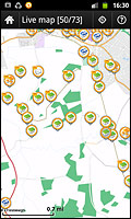
GPS Essentials
A very comprehensive navigation app which can record your route and
show it on a map, waypoints, routes and tracks saved and
imported/exported in KML or GPX format, eg. for viewing in Google
Earth. A dashboard can be customised from some 45 data widgets
(with key ones below the map) with values such as speed, distance,
average, ETA; even sunset and a stopwatch. There's a compass,
satellite sky view, graphing of speed and altitude over distance and an
interesting camera implementation.
We really thought this app was going to be a brilliant
replacement for our old Garmin Legend GPS receiver.
So you can imagine our disappointment when it failed to deliver - it
even had Mike crying into his beer! Firstly we encountered
problems adding the data widgets, or rather changing their
position. They couldn't simply be dragged over, we had to remove,
then re-add to required position. And this wasn't easy as the
'remove' icon didn't line up with the bit of screen estate where it
actually removed. Then it proved impossible to calibrate the
compass, no matter how much we rotated the smartphone through all its
axis' (we sure got some strange looks doing this!). Then there's
the small sized saved track details which can't be enlarged. But
the real deal breaker was when we couldn't get it to work with the
offline map, doh!
There's been some app updates over winter, so maybe things are
fixed. If so then this could be a very fine navigational app
indeed! Our tip: check back here around May (2013) and we'll
let you know if it's been fixed.
Update June '13: we've not revisited this app yet as My
Tracks (below) fulfills requirements).
Update Mar '14: we've still not revisited this app,
although the app is well liked in the Google Play community.
Update May '15: can't comment as we've not used app since.
My Tracks
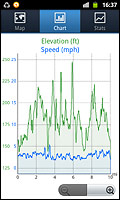 After ditching GPS
Essentials (above) this was our next choice. The app records your
path with a breadcrumb trail using different colours depending on
customisable speed bands. It shows some 15 data fields such as
speed, distance, elevation and times; and charts (see photo) elevation
and speed over distance (customisable too). And it announces key
data like distance travelled and average speed at time or distance
intervals (yes, customisable). And this is cool; it integrates
with Google Earth (if installed on your device) to fly you through your
route. Tracks and stats can be saved as GPX or KML files for
viewing on your computer's GE and saved tracks can also be aggregated,
handy for combining several days walking for example. After ditching GPS
Essentials (above) this was our next choice. The app records your
path with a breadcrumb trail using different colours depending on
customisable speed bands. It shows some 15 data fields such as
speed, distance, elevation and times; and charts (see photo) elevation
and speed over distance (customisable too). And it announces key
data like distance travelled and average speed at time or distance
intervals (yes, customisable). And this is cool; it integrates
with Google Earth (if installed on your device) to fly you through your
route. Tracks and stats can be saved as GPX or KML files for
viewing on your computer's GE and saved tracks can also be aggregated,
handy for combining several days walking for example.
And it all works extremely well! Clearly some real
thought has gone into this app, it can even preserve a track being
recorded over a battery change. And it puts an end to disputes
like how long you spent in the pub on that trek or what time you left
so-an-so point as the track's timings are preserved for later
analysis! The app is also aimed at fitness enthusiasts as it can
sync via bluetooth with biometric sensors to record heart rate and can
share created stats via social media.
While it doesn't support offline maps, the Google maps it uses
are cached, it seems in perpetuity. So using Wi-Fi we cache the
map of our proposed area of activity in the app before leaving home and
use it to record a day's walking activity. Our tip: hey, all
you walkers and cyclists out there, you'll love this app!
Update Mar '14: My Tracks only gets better, it can now
play more than one track in Google Earth.
Update May '15: tracks now exported as KMZ. We've
suffered several non-resumes of track recording after battery change.
Update May '16: our phone is no longer supported by this
app so no updates but it continues to work well.
OS Atlas (now UK Atlas)
Having an electronic Ordnance Survey map with us on our mobile device
sounded wonderful - no more fumbling with large paper maps when out
walking the trails! So we went straight for the paid version
(£1.99) as it promised map caching for offline use. But despite
indicating a cache size in the memory, it failed to load any
saved maps and greeted us with a black screen instead. The OS
maps it displays when online are fine (even if they take a while to
load), markers and paths can be overlaid and maps can be shown for
current location or searched by Grid Ref, postcode or inputted GPS
coordinates. We found a workaround by taking screenshots, but the
app's largish map overlays, such as zoom and refresh icons, can't be
disabled so block map detail. And there's been no updates for
this app in the 9 months we've used it. Our tip: it's pants,
don't bother with the full paid version (but try the free app first)!
Update June '13: despite an app update since review
it's still pants!
Update Mar '14: only one update since and all that did was
rename this to UK Atlas. We looked at OS MapFinder as an
alternative but that was a disaster too - bulky, clunky, poor
functionality, frequent crashes and pricey at £2 for tile (map) for
just a small area.
Update May '15: app no longer seems supported by the
developer; no updates since last.
Update May '16: splurge of updates since last, but icon
disappears from home screen and initial black screen on launching
(although works fine on our more recent tablet).
Skype
Skype is ideally suited to smartphone use, after all it's a
communication utility allowing free Skype-Skype calls, with video, to
be made. With Skype credit you can also call and text landline and
mobile numbers at cheaper rates (as you probably know!). One
thing missing is the Facebook integration that the desktop version has,
and we find the UI (user interface) not particularly well thought
out. Oh, and it shows up the low resolution of our phone's front
camera. But it all works well, after signing in with your Skype
account in the app you stay signed in for next time. We did
encounter one problem when our outgoing video showed mostly a blue
screen with just a hint of image along one edge, but this was quickly
fixed by an update. And usefully the video can be switched
between the front and rear camera. Our tip: use Wi-Fi for the
required online connection, using the mobile network you pay for the
data one way or another and defeat the object of free or cheap calls!
Update Mar '14: things get fixed and other things get
broken with various updates. Currently the biggest bug for us is
the similar pastel blue colour number text as background making it very
difficult to see to enter a phone number.
Update May '15: mostly OK, except one time we couldn't
hang-up a call when the app crashed and had to turn phone off/on to end
call!
Update May '16: no issues and runs well although we only
use for calls to landlines/mobiles (use tablet for Skype-Skype calls
and
video).
Aggregator
We tried three RSS reader apps (including the renowned RssDemon) but
this was the mediocre one we stuck with. It tends to duplicate
items when refreshing as it fails to ditch those previously displayed,
randomly fails to fetch all in a feed and randomly displays them out of
order. Maybe boring old RSS has had its day in these days of
Twitter... Our tip: if you can do without it, don't bother.
Right. Our own humble micbinks
RSS feed shown in the Aggregator app.
Tube Map
It displays the familiar London tube map of course and uses the GPS to
locate your nearest station. It can work out a route
incorporating line changes, and with a network connection gives current
service status and tube tweets. And it also integrates with the
Oyster card. Our tip: indispensable for all who use the
London Underground... how on earth did we cope before smartphone apps!
Update Mar '14: some subtle improvements but they've
ditched the Oyster card integration.
Update May '15: ditched this app now as it became plagued
by ads obscuring the map rendering it unusable.
Tesco Groceries
Here we have an electronic clubcard for scanning at the checkout,
points total, vouchers viewer and rewards ordering; a store finder,
groceries order, recipes and cooking tips and, of course, Tesco Direct
online store. But apart from the clubcard barcode it largely
mirrors the mobile website, apart from not having to login each
time. And it doesn't integrate with other Tesco aspects, such as
NFC payments or their in-store scan gun (Mike challenged store staff on
this, much to Belinda's embarrassment!). Our tip: use the
mobile version website instead, which works faster anyway.
Update Mar '14: sadly this one's deteriorated in many
ways in the last year. One update even required us to re-enter
our clubcard number rather than carry it over to the new version - not
very user friendly!
Update May '15: all's well again, we like viewing the
nicely laid out latest store deals.
Update May '16: keeps notifying of update but then says
our device is incompatible! But works well despite this.
Social Media apps
As you can imagine, there's plenty of mobile device apps for social
media networks! We've tried the apps for Twitter, LinkedIn,
Facebook and Flickr and all work in a similar fashion - they store your
account login, you can get new post notifications, check/post/share,
upload stuff and update your profile. They all have their quirks
though - we've suffered frustrating app crashes, not all content being
displayed, and upload failures. Our tip: handy if you get
withdrawal symptoms if more than an arm's length from your favourite SM
place, but the mobile version website of each often works better.
Disclaimer: we don't necessarily endorse these
Android mobile device apps or whether they'll work on your own
device. You should always evaluate apps yourself and make
your own decisions as to an app's suitability. micbinks disclaims
all responsibility.
© micbinks 2013-2016. Please ask permission if
you wish to reproduce any of our content.
|