|

|
GPS Sat Nav Review of the Garmin etrex Legend
Just before our Dorset holiday in 2005 we purchased a
portable Global Positioning System (GPS) Satellite Navigation receiver
(Sat Nav). We figured that such a gadget was a useful
accompaniment on our walks. Here's our review...
Also: sat
nav review article updates | Geocaching
| GPS website links
Other product reviews | Smartphone | Android Apps | Two Way Radios | Digital Camera | Panasonic
camcorder | Talkie Walkies
This review assumes a basic understanding
of the appropriate technology. Reviewed Sept 2005.
We've updated this Garmin etrex
Legend sat nav review with our latest findings in following years.
This page should now be considered an
archive resource (although the principles may still apply).
After some careful Internet research we choose the Garmin
etrex Legend GPS personal navigator as being suitable for our needs,
some further web research for an online supplier and our Sat Nav
arrived the next day - at 7.30 AM!
Background in a nutshell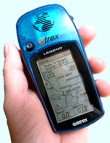
GPS uses a number of orbiting satellites, the signals from which are
picked up by the GPS Sat Nav receiver which can then compute your
position. This Sat Nav unit is designed for portable navigation
(eg. for walkers like us!) and resembles a mobile phone with a large
screen. It comes with a pre-loaded zoomable Basemap showing main
roads, railways, towns and cities. Locations can be added
(waypoints), either for the current location or for a projected
location, which can then be named and symbolised. Routes can then
be set between waypoints. When moving, it draws a breadcrumb
trail on the map and computes information such as current, average and
max speed, distance travelled, stopped and moving time. The
TracBack feature allows you to retrace your path along this
trail. Using the GoTo function to navigate to a pre-determined
location, such as a waypoint, the unit can display the time and
distance remaining until arrival and the ETA. A compass can be
viewed to navigate, this also shows the number of degrees needed to
turn to get back on track. The User Interface (UI) works much
like Windows does on a PC, with a number of pages and a clickable
joystick that functions like a mouse. Routes and trails can be
named and stored in its built-in 8Mb memory. Street level maps
can be purchased and loaded from CD (via a computer). There's
more to all this, but that's the basics!
Above right. Mike holds the GPS Sat Nav receiver
in his hand with the map page displaying our trail from our waypoint
marked cottage (by the little pan arrow) and running south of
Dorchester.
We try it in the car
We only had a day or so to learn about our GPS receiver and
how to work it before our holiday, however it was all fairly
straightforward. We first tried the Sat Nav on the car journey
from home to the holiday cottage and set the cottage location as a
waypoint on the Basemap, by inputting the National Grid Reference (NGR)
which in turn we obtained by inputting the Post Code into
multimap.com. Of course, we'd already marked our home location
waypoint during our learning, so all we needed to do was create a route
between the two and off we went! Despite the warnings implying
that it wouldn't pick up the satellite signals through the windscreen
(our windscreen is UltraViolet filtered and has a QuickClear element,
apparently both bad news at getting a signal) it worked perfectly lying
on the dash. Now Belinda's paper map navigational skills are
second to none of course, so we referred to the Sat Nav as confirmation
we were headed in the right direction and to view the miles remaining
and our ETA. We arrived at the cottage with the Sat Nav unit
saying we had another quarter mile and some 20 seconds to go, this can
no doubt be put down to the very rural location having a very wide Post
Code area!
|
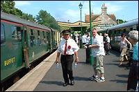
We tried the unit out on
The Swanage Railway.
|
We try it on the steam train
If you've looked at our Dorset holiday pages, you'll see
we enjoyed a steam train ride on The Swanage Railway. Using the
Sat Nav to monitor our train progress, it was interesting to notice
that the train just about managed to reach a maximum speed of 30.4
MPH! We had to balance the unit against the window to receive
enough oomph from the satellite signals, but despite it only being able
to 'see' half the sky, it received enough satellites to work. The
satellites couldn't help with more oomph for the train
unfortunately! We later tried the unit on a modern train (to
Brighton) and it registered a max of 88.2 MPH. Much more oomph!
|
We try it on our walks
We used the Sat Nav unit on our Hardy's Monument walk to see if it
could get us back to the cottage by using the TracBack feature.
This works by saving the breadcrumb trail we left on the outward
journey and selecting 'TracBack' from the saved track menu. The
time and miles to destination are shown by default on the navigation
page with a compass, we customised the display to additionally show the
ETA and To Course on the display, the latter shows how many degrees to
turn to maintain the correct direction. It worked brilliantly, we
purposely walked past a point where we should have turned right and the
Sat Nav unit compass arrow swung round to show the correct direction in
an instant. The ETA was within 1 minute too, not bad when the
trip computer has to work this out by constantly updating our speed
computation, including stops for a swig of water and a pee (Mike)!
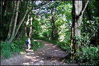 However, we found a problem using GPS on our
walk along the South West Coast
Path at Lyme Regis. As the walk was mainly in dense woodland,
the Sat Nav unit had trouble picking up the satellites signal. It
needs to receive at least three to work, the trees blocking its view of
the sky and the resultant trail was very patchy. We didn't try
the TracBack, but we expect it would have had trouble following such a
broken trail. However, we found a problem using GPS on our
walk along the South West Coast
Path at Lyme Regis. As the walk was mainly in dense woodland,
the Sat Nav unit had trouble picking up the satellites signal. It
needs to receive at least three to work, the trees blocking its view of
the sky and the resultant trail was very patchy. We didn't try
the TracBack, but we expect it would have had trouble following such a
broken trail.
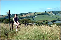 On our Fleet walk,
also along the S. W. Coast Path, the trail was complete as the footpath
was well out in the open. That was good for the Sat Nav unit, but
not for us in the hot hot sun! This was a circle route and the
GPS really came into its own when, having been forced along some
twiddly bits, we came out to a little road and our sense of direction
said to turn right. The GPS showed the start of our trail (where
we had parked the car) to be to the left, thus saving us from going
completely in the wrong direction! On our Fleet walk,
also along the S. W. Coast Path, the trail was complete as the footpath
was well out in the open. That was good for the Sat Nav unit, but
not for us in the hot hot sun! This was a circle route and the
GPS really came into its own when, having been forced along some
twiddly bits, we came out to a little road and our sense of direction
said to turn right. The GPS showed the start of our trail (where
we had parked the car) to be to the left, thus saving us from going
completely in the wrong direction!
An issue that manifested itself on our walks was with having
to hold the Sat Nav unit in your hand all the time in order to receive
a signal. This became a bit tiresome and sometimes awkward when
needing both hands to cross a style, for instance. We tried
carrying it in a bumbag and at the top of Mike's (why do I always carry
all the stuff) backpack, but in both cases the GPS signal was too poor,
even in open country.
|
We try it in the town
Oh dear! We experienced the same problem with
patchy satellite reception as in woodland. In both Lyme Regis and
Dorchester the buildings weren't particularly tall, but they were still
sufficient to block some of the sky and hence GPS signal. Worse
still, it became apparent that our positioning on the Basemap was way
off. At Dorchester train station our position was shown some 0.3
miles too far to the north. We should make it clear that our
location ie. grid ref, or Latitude and Longitude was always spot-on, it
was where it drew us on the map that was way out.
|
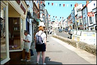
In Lyme Regis we had poor
GPS reception.
|
Some subsequent tests we did in Brighton showed us to be just
north of the main A259 coast road when we were out at sea at the end of
the quarter mile long pier! This inaccuracy rather makes it
superfluous of GPS being capable of an accuracy to, typically, 12
meters and certainly doesn't enthuse us to buy the MapSource CDs to
give street level mapping. Would it ever show us in the right
street? Come to that, would it receive enough satellite signal in
town anyway??
Batteries
We've added this bit as we experienced problems in this area
too. The Sat Nav receiver takes two 'AA' sized batteries, either
dry or rechargeable cells. We used modern Nickel Metal Hydride
(NiMH), convenient for us as our digital camera and MP3 player use the
same cells. We found that fully charged batteries barely lasted
the day out using the Sat Nav unit from, typically, 10am until
6pm. There's a battery saver mode which did extend battery life,
but the trade off was less frequent satellite signal checking,
resulting in even more patchy trail drawing. We tried
setting the backlight to the minimum too, to conserve power.
However, we needed to carry spare cells (fortunately a battery change
doesn't loose data as it's stored on internal flash memory) to ensure
continued operation all day. Keeping enough batteries charged for
a day's walking became a logistical challenge with only one charger
able to charge a pair of NiMH's for 8 hours at any one time. Some
nights Mike (why me!) was changing batteries in the middle of the night
to provide enough for the next day (yawn!). Of course, the easy
solution is to buy another charger, they're cheap enough after all, but
surely if mobile phones can easily last in excess of one day on a
charge then so should a little GPS Sat Nav unit.
Other features briefly
The Sat Nav receiver also has a calculator, area calculator
(eg. walk round a field and calculate the acres), distance calculator,
hunt and fish calculator, calendar with notes, sun/moon set/rise times
(can be projected for different locations and days), a favourites store
and a find feature, eg. find a town which it then describes.
|
Good Points...
|
Bad Points...
|
- Easy to get to grips with
- Good at navigating to destination
- Comprehensive trip computer
- Picks up GPS signal well behind glass
- Waterproof
|
- Poor integration with Basemap
- Poor GPS reception in woods, city, etc
- Limited battery life for all day use
- Limited number of routes/tracks store
- MapSource CDs expensive (£100)
|
 Our overall
conclusions Our overall
conclusions
The Garmin etrex Legend GPS Sat Nav unit we used does have
some very useful features for walkers, such as its ability to get you
back to your starting point or to guide you to a pre-determined
point. It also provides reassurance that you're going in the
right direction when otherwise you'd have no idea.
We do have some serious concerns regarding its ability to correctly
show the position on the Basemap, plus its ability to receive a
consistent satellite signal in wooded and built-up areas. Not all
walking is done along open paths!
We suspect the same situation here as experienced with cell phone
technology in the late 1980s. The system was initially designed
for vehicle use, using an external aerial. Cell coverage would
drop out with early handheld portable phones. The situation will
surely improve with satellite strength and coverage, making handheld
GPS a better proposition in say, a few years time. There's also
the new Galileo navigation system in development, see links
below. An early adopter of technology is often disappointed.
For now, by all means purchase a handheld GPS Sat Nav receiver, but
beware of its limitations and be sure to take an old fashioned paper
map with you too!
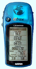
Left. The trip computer page showing trip and
total miles, moving and stopped time and max and average speeds. The
'speed' field on the left only registers when moving.
Check out our Garmin
etrex Legend review updates in following years.
You may also like to see how we use Sat
Nav for Geocaching.
You can find the Garmin website at: www.garmin.com/en-GB
Other brands of Sat Nav include TomTom
and Magellan.
Also check GPS software and apps for
mobile devices.
GPS related website resources (last checked & updated 2026
- but some are rather dated!):
How Does GPS Work? - detailed explanation.
GPS
training - UK training courses in global positioning systems.
Galileo - European navigation system in development which uses
30 satellites to drastically improve signal availability and positional
accuracy.
What is Galileo - European Space Agency site on Galileo.
Ordnance
Survey - Britain's mapping agency.
Geocaching - all about the worldwide treasure hunting navigational
hobby.
Please inform us if you find deadlinks above.
© micbinks 2005. Please ask permission if you
wish to reproduce any of our content.
|